About this crossing
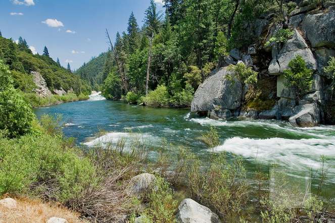
The South Fork Kings River ford is one of the most consequential water crossings on the John Muir Trail and Pacific Crest Trail, sitting at roughly 10,040 feet in Kings Canyon National Park. Southbound from Happy Isles the crossing falls at approximately JMT mile 153; northbound from Whitney Portal it sits near mile 58. The JMT/PCT crosses the South Fork Kings River twice in this section as the trail threads through the valley floor between Mather Pass to the south and Pinchot Pass to the north.
Geography. The ford sits in a broad, glacier-carved valley known as Upper Basin. The river originates at 11,601 feet at an unnamed lake south of Mather Pass and west of Split Mountain. By the time it reaches the JMT crossing it has collected snowmelt from the entire Upper Basin, including drainage from the slopes of Mather Pass (12,080 feet), the cirques below Split Mountain, and numerous unnamed tarns. Nearby landmarks include the Bench Lake trail junction (mile 156.2, 11,000 feet), Lake Marjorie (mile 157.7, 11,200 feet), and the Taboose Pass trail junction (mile 155.1, 10,000 feet) — an emergency exit east to the Owens Valley.
Typical character (mid-July through September, normal years). A 30-to-50 foot crossing of cold, clear snowmelt running knee to waist deep with a rocky streambed and moderate-to-swift current. The water is uniformly cold — low 40s Fahrenheit even in August. Most parties cross in under five minutes using trekking poles planted upstream for stability.
Peak character (late May through mid-July, and into August in heavy-snow years). During the record 2017 Sierra snowpack, Andrew Skurka described the South Fork Kings as impassable at the standard crossing; his party avoided it entirely by staying high on the east side of the river. The river's large drainage basin means it responds violently to diurnal snowmelt cycles: afternoon flow can be double the early-morning volume. In peak runoff the crossing becomes waist- to chest-deep with powerful, opaque current and floating debris. Multiple trip reports from 2017 and 2023 (another heavy-snow year) describe the main ford as impassable during afternoon hours.
The South Fork Kings drainage encompasses 476 square miles of watershed — the largest headwater of the entire Kings River system. At the JMT crossing the river has already gathered enough volume to be a serious obstacle even in moderate years. The combination of large watershed, high-elevation snowfields that melt late into summer, and the absence of any bridge makes this one of the JMT's most persistent hazards. There is no bridge at either crossing point.
Decision framework. In a normal year after mid-July, the main trail crossing is straightforward with trekking poles. In a heavy-snow year or before mid-July, take the east-side use trail bypass — it avoids both fords entirely with modest added time. If the main crossing reads thigh-deep or the current is visibly opaque, do not attempt it. The Taboose Pass trail at mile 155.1 provides an emergency exit east to the Owens Valley if conditions are impassable.
Location
Alternate Crossing
East-side use trail bypassSafer Option
The east-side bypass is the best-documented alternate for the South Fork Kings River fords. Rather than fording the river twice at the standard trail crossings, hikers stay on the east side of the river and walk through open meadows and subalpine woodland, avoiding both fords entirely. Andrew Skurka's hazardous-creeks guide notes that the South Fork Kings south of Mather Pass is easily bypassed by hiking on the east side of the river on an existing use trail. Multiple 2017 trip reports describe a 2–2.5 mile use trail (unmaintained but visible) that connects the trail on both sides of the crossing zone. In early season when snowpack remains, an additional option exists: crossing at the river's headwaters just below Mather Pass, where snow bridges may still span the much-narrower channel. Skurka's 2017 early-season party used this approach successfully in mid-June. This option disappears by July in most years as the snow bridges collapse. For hikers arriving via the Taboose Pass trail from the east, the bypass is even more natural since they are already on the east side of the river. Use the bypass whenever the main ford reads thigh-deep or deeper, whenever the current is visibly opaque or audibly moving rocks, during afternoon melt surges, or for any solo hiker in a high-water year. In a record-snow year like 2017 or 2023, take the east-side bypass unconditionally — the trail crossings can be impassable even in early morning.
Incident History
⚠ Known Incidents
In July 2017, during the highest Sierra snowpack season in recorded history, PCT thru-hiker Rika "Strawberry" Morita, age 32, from Osaka, Japan, drowned at the South Fork Kings River in Kings Canyon National Park. Morita was 5 feet tall and weighed 100 pounds (Rafu Shimpo, 2017). Morita was last seen alive on or about July 8, 2017, by fellow hikers approximately four miles south of Glen Pass near the Rae Lakes area (KTLA, 2017). She had been traveling with companions but continued ahead alone; the group believed she would wait for assistance at the upcoming river crossings but never saw her again (Rafu Shimpo, 2017). On July 22, Morita was reported missing — already five days overdue in Bishop. On July 23, a group of PCT hikers discovered her body submerged in the South Fork of the Kings River at an alternative water crossing at approximately 10,000 feet, just north of Bench and Marjorie lakes (KTLA, 2017). NPS officials stated that rapid snowmelt continued at high elevations, resulting in dangerous water crossings and persistent snow and ice. A recovery mission was completed July 24 (PCTA, 2017). Morita's death was one of at least four fatalities on the PCT that summer. Chaocui "Tree" Wang drowned in Rancheria Creek in Kerrick Canyon, Yosemite, and Marvin Novo died of suspected heat-related causes near Whitewater Preserve (SnowBrains, 2017). Sources: - KTLA (2017): "Body of Missing Hiker Found in River at Kings Canyon" https://ktla.com/2017/07/25/dead-body-of-32-year-old-missing-hiker-found-in-river-at-kings-canyon-national-park/ - Rafu Shimpo (2017): "Missing Japanese Hiker Found Dead" https://rafu.com/2017/07/missing-japanese-hiker-found-dead/ - SnowBrains (2017): "Pacific Crest Trail Claims Two More Lives" https://snowbrains.com/pacific-crest-trail-claims-another-two-lives/ - PCTA (2017): "Sadness abounds with news of more deaths on the PCT" https://www.pcta.org/2017/sadness-deaths-pacific-crest-trail-50680/ - Skurka Adventures: "PSA: Hazardous High Sierra creeks" https://andrewskurka.com/psa-hazardous-high-sierra-creeks-list-map-alternates/
Safe Fording Technique
Before you step in
- Unbuckle your pack hip belt and sternum strap — if you fall, you need to be able to shed the pack fast.
- Scout upstream and downstream. Wider, slower, braided sections are almost always safer than the trail-direct line.
- Cross early in the day during snowmelt season — water is lowest overnight and peaks mid-to-late afternoon.
- Face upstream, sidestep across. Use trekking poles planted upstream as a third and fourth leg.
- Keep boots on. Wet boots dry. Broken feet end trips.
- Turn back if water is above your thighs and moving swiftly. No campsite is worth a drowning.
