John Muir Trail — Logistics
On this page ↓
Getting There
- Fly into Reno–Tahoe or Fresno-Yosemite (FAT); drive or YARTS bus in.
- Most hikers shuttle between Whitney Portal and Yosemite Valley to avoid a 300-mile car repositioning.
- Wilderness permits are required and sell out months in advance.
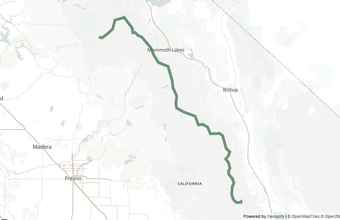
The John Muir Trail runs 211 miles between Happy Isles in Yosemite Valley (northern terminus) and Whitney Portal below Mt. Whitney (southern terminus). Most northbound (NOBO) hikers start in Yosemite Valley; southbound (SOBO) hikers finish there. Gateway towns on the east side — Mammoth Lakes, Bishop, and Lone Pine — cluster along US-395 and are served by YARTS and Eastern Sierra Transit. Yosemite Valley is served by YARTS from Mammoth, Merced, and Fresno. If you drive yourself to one end, you'll need a shuttle service (see below) to get back to your car — booking ahead in peak season (July–September) is strongly recommended.
Stream Crossings
Significant fords along the route. Conditions vary dramatically by snowpack and time of year — check current reports before a high-water year attempt.
Mono CreekMile 87.2
Bear CreekMile 97.1
Evolution CreekMile 115.5
South Fork Kings RiverMile 155.6
Gateway Towns
Drive-in towns for the night before and after your hike, ordered along the route.
| Town | Nearest trailhead | Drive time | Elevation | Nearest airport |
|---|---|---|---|---|
| Yosemite Valley | Happy Isles (NOBO start) | — | 4,000' | Fresno (FAT), ~2h |
| Mammoth Lakes | Red's Meadow / Devils Postpile | 30 min | 7,880' | Mammoth (MMH) / Reno (RNO) |
| Bishop | Kearsarge Pass resupply | 1h to trailheads | 4,150' | Bishop (BIH) / Reno, ~4h |
| Lone Pine | Whitney Portal (SOBO finish) | 15 min | 3,730' | Reno, ~5h |
Yosemite Valley
Mammoth Lakes
Trail-Side Stops
On-trail resorts and resupply stops. Capacity is limited — book well ahead.
Red's MeadowMile 58.7
Shuttles & Transport
Transport services connecting trailheads to gateway towns, airports, and other trailheads.
Whitney Portal Store Shuttle
YARTS
Tuolumne Hikers Bus
Red's Meadow Shuttle
Permits
A wilderness permit is required to thru-hike the JMT. NOBO permits from Yosemite are issued by Yosemite National Park via the 24-week advance lottery on recreation.gov. Demand far outstrips supply at Happy Isles during July and August; alternate NOBO trailheads (Lyell Canyon, Sunrise Lakes) have better odds.
SOBO permits starting at Whitney Portal (Mt. Whitney Zone) are issued by Inyo National Forest via the February Mt. Whitney Lottery. Continuous-use permits let you camp in Whitney Zone the day before summit; same-direction thru-permits cover the rest of the trail.
Black bear canisters are required throughout the trail. Plan resupply stops carefully — carrying capacity between MTR, VVR, and Red's Meadow determines canister choice.
FAQs
When is the best time to hike the JMT?
Mid-July through mid-September is the mainstream window: snow is usually cleared from the high passes, fords are moderate, and the weather is relatively stable. Earlier starts (late June) face deep snow on Forester and Muir passes and dangerous high-water fords. Later starts (late September) bring shorter days, colder nights, and early-season storms.
How do I get a JMT permit?
For NOBO starts from Yosemite, enter the 24-week-ahead lottery on recreation.gov. Permits release 24 weeks before your intended start date; demand for Happy Isles is highest. For SOBO starts from Whitney Portal, enter the February Mt. Whitney Lottery on recreation.gov or pick up a continuous-use permit that covers both Whitney Zone and the rest of the JMT.
Do I need a bear canister?
Yes — canisters are required on the entire JMT, from Yosemite through Sequoia & Kings Canyon. BearVault BV500 and Garcia canisters are the most common sizes; ultralight hikers sometimes use the BV450 with shorter resupply windows. Canister rental is available in Yosemite Valley, Mammoth Lakes, and online.
NOBO vs. SOBO — which direction should I hike?
NOBO (Happy Isles → Whitney) is the "classic" direction: gradual elevation gain, you finish on Mt. Whitney's summit. SOBO (Whitney Portal → Happy Isles) puts the hardest climb first and acclimatizes you quickly, and SOBO permits are often easier to obtain. Both are great — choose based on permit availability and logistics.
Planning Resources
- NPS: John Muir Trail (Yosemite)Official NOBO permit info and trail conditions
- Inyo National ForestSOBO permits, Whitney Portal trailhead, Mt. Whitney lottery
- Pacific Crest Trail AssociationJMT overlaps the PCT for most of its length
- ← Back to John Muir Trail overview
